Category Archives: Altocumulus

Fallstreak holes over Missouri

FallstreakHole_KarlKischel_Williamsburg_Missouri_USA_18Feb2016_7

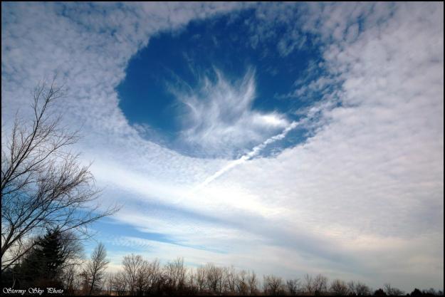
Fallstreak Hole, Contrail, Altostratus (Karl Kischel, Williamsburg, Missouri, 18 Feb 2016)

Hole punch clouds have fascinated sky watchers, scientists, and pilots since the 1940s. Nearly circular in appearance, the hole punch cloud can have streams of ice falling from its center (as in Karl’s picture), thereby giving a subset of these clouds the name fallstreak holes. These beautiful, fascinating atmospheric phenomena are created by aircraft penetrating cloud layer. In Williamsburg, it’s not unlikely to see planes ascending and descending due to the nearby busy St. Louis airport.

Fallstreak holes require a specific cloud type: mid-level altostratus or altocumulus clouds that exist between 6,500 and 20,000 ft above ground. At these altitudes, temperatures are well below freezing, but water droplets exist in liquid form at these sub-freezing temperatures, called supercooled water. To freeze, liquid water droplets need either a nucleus to freeze upon (either ice itself or a particle in the air such as dust, bacteria, fungal spores, volcanic ask, etc.) or temperatures to be below -40 degrees C to freeze spontaneously without a nucleus.

So how does an aircraft flying through supercooled water lead to freezing of drops and ultimately a fallstreak hole?  We know that when aircraft fly high in the sky, at very cold temperatures (i.e., below -40 degree C), the water vapor in the jet engine exhaust rapidly freezes to form contrails across the sky, as can be seen in the photo above. But the key for fallstreak holes is the localized cooling that’s created around propellors and wings. Propellors push air outwards, causing the air to expand, which lowers the pressure and therefore cools the air. For jets, lower pressure exists above the wing compare to below, again leading to localized cooling of the air. This can cool the air to temperatures below -40 degree C, even when the aircraft is flying at lower temperatures, causing the supercooled water droplets in the cloud layer to spontaneously freeze where the aircraft passes through.

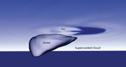
These ice crystals begin to grow at the expense of the nearby supercooled droplets, referred to as the Bergeron-Findeisen process. The vapor left behind by the evaporated supercooled droplet deposits onto the ice crystals thereby, along with the remaining supercooled droplets freezing on impact, allowing the ice crystals to grow.

bergeron_s

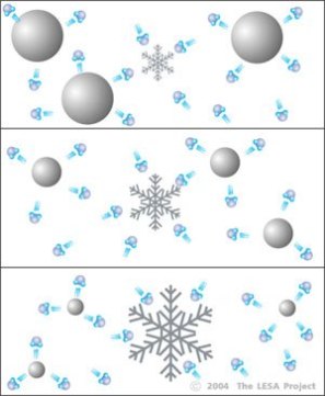
Drawing representing the Bergeron-Findeisen process: Ice crystals growing at the expense of water droplets


The freezing processes gives off heat, warming the surrounding environment.

latent_heat_schem


This warmer air rises, cools, and creates small circulations where downward (subsiding) air compensates for the locally rising air where the ice crystals are growing. The subsiding air warms, creating the hole.

Screen Shot 2016-02-21 at 8.08.06 PM

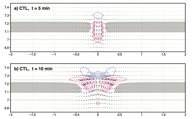
Computer simulations of a hole punch cloud showing heating (red), cooling (blue), and the corresponding circulations (black arrows). From Muraki et al. (2015).


These holes can spread for hours, lasting more than 4 hours at times, and the ice crystals can grow so large that they start to fall as snow, leading to the name fallstreak hole.

FallstreakHole_KarlKischel_Williamsburg_Missouri_USA_18Feb2016_3

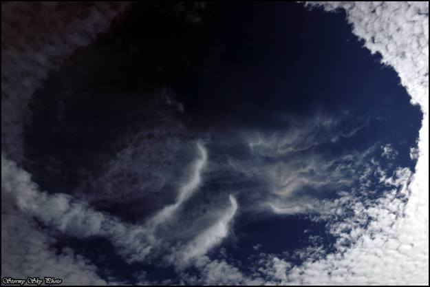
Zoomed in view of the hole punch cloud showing the fall streaks (Karl Kischel, Missouri, 18 Feb 2016)


On 18 February 2016, Karl was lucky enough to photograph two of these hole punch clouds over Williamsburg, Missouri.

FallstreakHole_KarlKischel_Williamsburg_Missouri_USA_18Feb2016_6

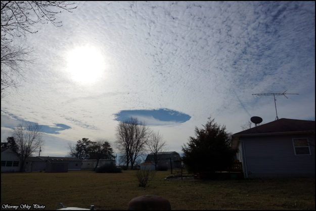
Two fallstreak holes, Karl Kischel, Williamsburg, Missouri


These fallstreak holes could also be seen on visible satellite imagery! Those in the circle are the same ones Karl was photographing. Notice there’s a third one nearby. In fact, because these are visible from satellites, scientists have used high-resolution satellite data to look at the occurrence of fallstreak holes around major airports in the U.S. They found that they occur 3-5% of the time on average per year, and about 15% of the time during the winter (when we’re most likely to see these altocumulus/altostratus cloud layers).

FallstreakHole_KarlKischel_Williamsburg_Missouri_USA_18Feb2016_satellite

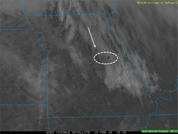
GOES Visible Satellite image from 15:15 UTC on 18 February 2016 showing the fallstreak holes.

Besides wanting to know your chances of seeing these beautiful hole punch clouds in the sky, why is it important to know how often they occur? There’s an argument that the increased snow that falls from the holes could mean more de-icing would be required at the airport before takeoff.

Screen Shot 2016-02-21 at 8.21.42 PM

Computer simulation after 60 minutes from when ice was introduced into the cloud layer. From Heymsfield et al. (2011)


Thanks for the great pictures, Karl! Enjoy additional photos he took from that day.

Vog in paradise

Vog? What is that? Well, fog is tiny suspended droplets in the air, while vog are suspended particulates from volcanoes. This volcanic air pollution casts a hazy scene near the Hawaiian Islands as sulfur dioxide from the volcanoes mix with oxygen and water vapor in the atmosphere to form tiny sulfate particles. These particles can reflect the sunlight, making the extent of vog detectable by satellites, such as in this example from 2008.

Kilauea2_AMO_2008338

Image from MODIS on 2 December 2008 showing the milky haze around the Hawaiian Islands indicating vog. Image courtesy of NASA’s Earth Observatory: http://earthobservatory.nasa.gov/IOTD/view.php?id=36089

While the vog in this example was an extreme case, from the ground, these particulates can create a hazy view. This picture was taken by Stephen Green on a plane near the Kona airport on the Big Island of Hawaii, showing an example of the haze.

Cumulus_humilis_Haze_Inversion_ImaginscapePhotography_KonaHawaii_1Apr2015

Stephen Green (Imaginscape Photography), Kona, Hawaii, 1 Apr 2015

Notice how the haze is trapped in a shallow layer near the ground. This happens because of what’s called an inversion, where the temperature increases with height instead of typical decreasing. This “trade inversion” provides a cap to the vertical growth of clouds, which is why the cumulus clouds in this photo remain shallow in this layer. This stable scenario forms when winds are weak, so the vog persists in this shallow layer of stagnant air near the surface. Balloons launched twice a day from locations around the U.S., including Hawaii, carry instruments into the atmosphere that measure the vertical profile of temperature, moisture, pressure, and winds. An example of these measurements from Hilo, on the day this photo was taken (1 April 2015), shows the existence of this temperature inversion, with dry air above it and moist, relatively calm conditions below.

2015040112.91285.skewt.HiloHI_annotated

A study by Guanxia et al. [Guangxia Cao, Thomas W. Giambelluca, Duane E. Stevens, and Thomas A. Schroeder, 2007: Inversion Variability in the Hawaiian Trade Wind Regime. J. Climate20, 1145–1160. http://journals.ametsoc.org/doi/full/10.1175/JCLI4033.1] used these observations from Hilo and from another location on the island to determine how often this trade wind inversion occurred. They found that the inversion occurs approximately 82% of the time at each station. The following figure from their paper also shows the height and strength (determined by temperature) of the inversion varies based on time of the year.

i1520-0442-20-7-1145-f06

Annual cycles of the (a) inversion base height and (b) inversion strength at Hilo and Līhu‘e, Hawai‘i, based on data from 1979–2003. (Figure 6 from Guangxia et al. 2007)

Here is another picture from Stephen of an obstructed view of the sky due to vog. In this example, haze from the Pu’u O’o eruption limited the view of lenticular clouds near Mauna Kea on the big island on 8 February 2015.

Lenticular_Haze_ImaginscapePhotography_BigIslandHI_HazeFromPu'uO'oEruption_8Feb2015

Stephen Green (Imaginscape Photography), Hawaii, Feb 2015

These inversions aren’t present all of the time as weather systems can move through and eliminate the stable layer, provide moisture, and remove the vog particulates. In these cases, the view on the big island is clearly stunning.

Sunset_ImaginscapePhotography_BigIslandHI_9Mar2015

Stephen Green (Imaginscape Photography), Hawaii, March 2015

The upside to this inversion is that the vog and clouds are trapped in the lower part of the atmosphere, leaving a crystal clear view of the sky above. The Mauna Kea observatory is truly a sight to behold and we’ve had the fortune to gaze at the stars from that location on one of these clear nights.

Check out more of Stephen’s pictures on his Facebook page: https://www.facebook.com/stephengreenimages?fref=ts

Fallstreak hole over NY

FallStreakHole_Altocumulus_stratiformis_DanielLinek_OneontaNY_Oct2011

Daniel Linek
Location: Oneonta, NY
Date: October 2011

The sky over Oneonta on this autumn evening was covered with an altocumulus stratiformis cloud layer. These mid-level clouds (typically located between 6,500 and 20,000 feet or 2,000 to 6,000 meters above the ground), are primarily made up of water droplets, but at these levels in the atmosphere, where temperatures are below freezing, some of this water remains in liquid form: this is called supercooled water. In order for these supercooled droplets to freeze, the temperature has to either be below -40 degrees (Celsius or Fahrenheit) or there needs to be something other than water (a tiny particle) to serve as a nucleus to freeze upon. Once this freezing gets started, a process that gives off heat, nearby supercooled droplets evaporate at the expense of the growing ice crystals creating a hole in the cloud layer. As these ice crystals grow then begin to fall, you can see them in the center of the hole, giving this phenomenon the name Fallstreak Hole (also referred to as a “Hole punch cloud”).

But what kicks off the freezing process? While this could happen naturally, research has found that aircraft flying through this supercooled cloud layer can set off freezing. As air flows around airplane propellor tips and over jet wings, it can cool in a localized area, at times to temperatures colder than the -40-degree threshold required for spontaneous freezing of drops. This sets off the freezing process, which, as previously mentioned, gives off heat. Computer simulations (described in a research article in Science) indicated that this process can induce vertical motions in the atmosphere than can least more than an hour, leading to the expansion of the hole.

Notice how the hole in this particular picture looks more like a line. This is due to the lower angle through which the aircraft flew through the clouds.

Reference: Heymsfield et al., 2011: Formation and Spread of Aircraft-Induced Holes in Clouds. Science, Vol. 333 no. 6038, pages 77-81.

Wave clouds over Colorado

WaveCloud_JessicaSueMillsMcGee_WestminsterCO_28Jun2014_2 WaveCloud_JessicaSueMillsMcGee_WestminsterCO_28Jun2014_3 WaveCloud_JessicaSueMillsMcGee_WestminsterCO_28Jun2014_4 WaveCloud_JessicaSueMillsMcGee_WestminsterCO_28Jun2014

Jessica Sue Mills McGee
Location: Westminster, CO
Date: 28 June 2014

When strong stable air flows perpendicular to mountain ranges, an oscillation is created downstream of the mountains. These peaks and valleys in the air are trapped within the stable layer, and wherever there’s enough moisture, clouds can form. These clouds commonly appear in the mid-levels and are lens-shaped, appearing like flying saucers at times. They are called Altocumulus lenticularis and a particularly good example of this cloud type can be seen in the top right photo above. In the other photos, you can see the wave clouds over Westminster, located to the east of the Rocky Mountains. The strong zonal (west-to-east) airflow across the mountains created this beautiful sight at sunset while lower levels of the atmosphere remained dry.

Here is a diagram from the COMET program that helps show what we mean by oscillating air in a stable environment.

mountain_wave

Altocumulus clouds spreading across the FL sky

Altocumulus_floccus_stratiformis_KimberEdmondson_centralFL_Jun2014

Kimber Edmondson
Location: Central FL
Date: June 2014

An early morning over FL featured a sky of altocumulus clouds. The species these altocumulus clouds are stratiformis, reflecting their spatial extent across the sky. Often times this happens in advance of a cold front, with the clouds continue to spread across the sky and thicken. While there’s no precipitation associated with these clouds, they can be a sign of some to come.

Beautiful mix of clouds in Norway

Cirrus_Altocumulus_Altostratus_Cumulus_CrepuscularRays_HannePernilleRyel_BjornemyrNorway_27Jun2014

Hanne Pernille Ryel
Location: Bjørnemyr, Norway
Date: 27 June 2014

Wow, what a mix of clouds over Norway in this picture! At the highest levels, cirrus clouds smear the sky as the wind carries the ice crystals, while mid-level altocumulus clouds spread out across the sky with their darker appearance creating a great contrast against the cumulus clouds being illuminated by the setting sun. These clouds block the sun to create upward-directed crepuscular rays! Crepuscular means “referring to twilight”, which is appropriate as it forms in the waning daylight hours over Norway. This mixture of clouds indicates moisture at many levels and if, especially, the mid-level cloud layer continues to increase in coverage across the sky, it could mean more inclement weather in store.

The calm before the storm in FL

Altocumulus_floccus_KimberEdmondson_CentralFL_27Jun2014_morning

Kimber Edmondson
Location: Central Florida, U.S.A.
Date: 27 June 2014

Before the nearly daily afternoon thunderstorms fired up over central Florida on 27 June 2014, this patch of altocumulus clouds were observed in the early morning hours. Indicating unstable conditions and moisture at these mid-levels, they also allowed enough sun to shine through to aid the heating-induced circulations over this state that creates frequent afternoon storms. Altocumulus clouds can typically be found between 6,500 and 20,000 feet (2,000 to 6,000 meters) above the ground.

A mixture of clouds in NW Taiwan

Cumulus_Altocumulus_lenticularis_Cirrus_Ming-HwaTang_MiaoliCityNWTaiwan_17Jun2014

Ming-Hwa Tang
Location: Miaoli City, Taiwan
Date: 17 June 2014

What a fun mixture of clouds over northwest Taiwan on this late spring afternoon! High above, the faint, nearly transparent clouds are Cirrus clouds made up of ice crystals. Moving down to the mid-levels are Altocumulus clouds. Note that they are slightly lens-shaped. This indicates the lenticularis variety, or more commonly referred to as Lenticular clouds. They form when relatively stable air flows over mountains, which in this case are part of the Central Mountain Range oriented N-S across this country. Heating of these mountains peaks, however, allows the sub-tropical moist air to rise to produce the shallow cumulus clouds over the high terrain. The presence of the more stable lenticular clouds aloft suggest that these cumulus clouds will be limited in vertical growth.

This is an example of Altocumulus stratiformis translucidus. Wow, that’s a mouthful! Let’s break it down a bit. Altocumulus are mid-level patches of clouds (cloudlets), existing between 6500 and 20,000 ft, that are mostly made of water droplets. They indicate some instability at that level. Stratiformis is its species because they are spread out over a large area. Note how they are different from the layered altostratus clouds because you can still make out the individual cloudlets. The variety Translucidus means that you the clouds are thin enough to see the sun through. If these were to continue to spread out and thicken to altostratus, it would be an indication of more inclement weather to come.

Angela Rowe
Location: Oahu
Date: February 2011

Altocumulus_stratiformis_translucidus_AngelaRowe_OahuHawaii_Feb2011