This is the place to show off your pictures of the sky, identify clouds, and to discuss how specific cloud types form and what they can tell you about current and future weather.
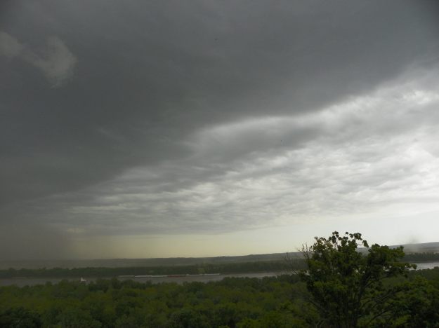
Eileen Lenkman, 7 May 2016, eastern Missouri looking across Mississippi River toward Illinois
On May 7, 2016, a line of storms moved through the midwest. Eileen Lenkman shared a series of photos from eastern Missouri as the storms moved from the NW toward the SE.
In this first photo, the storm can be seen approaching the area.
Eileen Lenkman, 7 May 2016, eastern Missouri looking toward Illinois
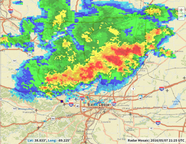
Composite radar imagery at this time shows the extent of this precipitating system as it moves toward the St. Louis area.
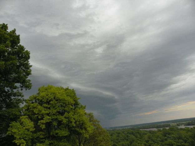
In the next photo, the heavily raining portion of the storm appears in Eileen’s view.
Eileen Lenkman, 7 May 2016, eastern Missouri looking toward Illinois
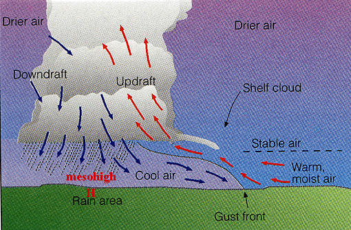
The rain locally cools the air, which spreads out near the ground away from the raining core of the storm. The leading edge of this rain-cooled air is referred to as a gust front and is typically accompanied by strong winds.
Schematic showing the gust front at edge of rain-cooled air
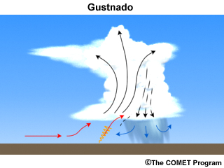
Not only is there a marked temperature distance across the gust front between the rain-cooled air behind it and the warm, moist air ahead, difference in wind speed and direction behind and ahead of the gust front can create considerable horizontal wind shear across that boundary far out ahead of the raining core of the storm. The warm, moist air is lifted up and over the colder dense air behind the gust front. This upward motion can tilt and vertically stretch the small-scale vortices that can form along the edge of the gust front due to the horizontal wind shear, creating a spinning vortex that can extend upward from the ground; this is casually referred to as a “gustnado.”
This shallow, short-lived vortex may only extend upward 10s of feet above the ground with no apparent connection to the cloud above. Away from the raining core, a debris cloud or dust whirl is seen near the surface. Wind speeds can reach 60-80 mph in these gustnadoes, but they are not considered to be a tornado as they are not associated with any sort of parent rotation in the cloud above.
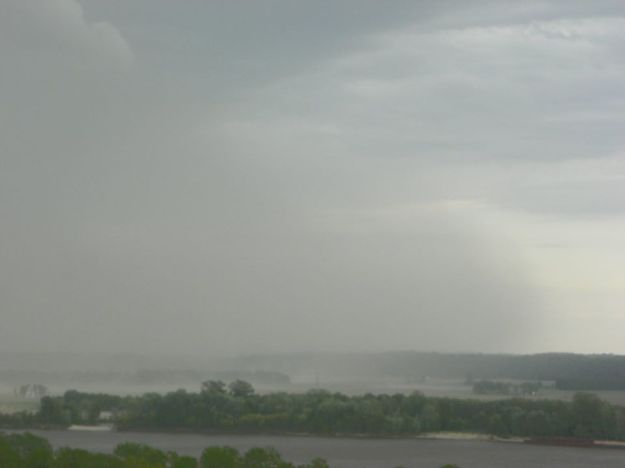
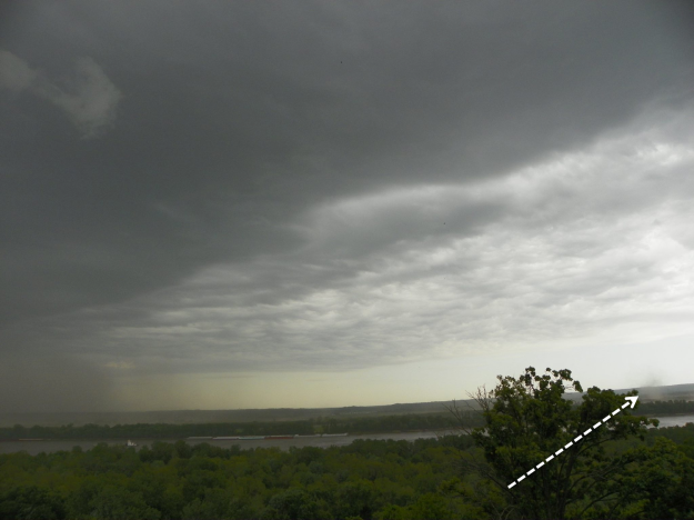
On 7 May 2016, when the storms were moving near St. Louis, Eileen Lenkman captured one of these gustnadoes on camera.
In this photo, the raining core can be seen to the far left of the photo while out to the right the small debris whirl near the surface can be seen at presumably the leading edge of the gust front.
“Well that looks ominous” said Meredith O’Neill Muminovic as she took this photo of an approaching storm on 26 April 2016 in St. Louis, Missouri. The shelf-like appearance of the storm’s leading edge indicates strong winds as rain-cooled air lifts warmer, moist air out ahead of it. At the time of this photo, a Severe Thunderstorm Warning was in effect as 60+ mph winds were reported in the area, as well as hail 1″ in diameter covering the ground in some locations.
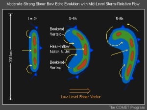
The corresponding radar image from around this time shows that the storm Meredith photographed was part of a line of storms moving across Missouri, referred to as a squall line. The red and orange areas in radar reflectivity indicate the heaviest rain, with weaker but widespread rainfall following behind the leading edge. The yellow box around St. Louis indicates the area under the Severe Thunderstorm Warning, which is aligned where the squall line appears bowed.
The bow echo is commonly associated with strong, often damaging winds at the surface. Much research has gone into studying bow echoes, leading us to understand how they form and the resulting weather they cause. The bow structure is strongly related to the wind shear of the environment these storms form in, meaning how the winds change direction and speed with height.
Underneath the storm, turbulent motions are also present, as nicely captured by this video by Billy Reed in St. Louis around the time of Meredith’s photo.
Above, the clouds are deep and, individually, take on the classic structure of a cumulonimbus. In this schematic from the National Weather Service’s online school, JetStream, you can see that where the radar reflectivity shows the heaviest rain with the reds and oranges, the cloud is deep. Warm, moist air flows into the storm from out ahead of the squall line, fueling the strong updraft which hits a stable layer aloft, usually the tropopause, and creating an overshooting top. Within those strong updrafts, large hail can grow as supercooled liquid water freezes upon ice. Smaller Ice crystals can be carried outward to form the anvil of the cumulonimbus or fall and melt behind the updraft, contributing to the heavy rainfall at the surface and lighter rain extending behind the main leading line.
Schematic showing a vertical cross section of the cloud, precipitation, and air motion associated with the radar image of a squall line (from National Weather Service)
The rain cools the air near the surface relative to the surrounding environment. This rain-cooled air rapidly moves outward away from the rainy core. The leading edge of this dense, cool air is referred to as a gust front.
Labeled schematic of a squall line storm from University of Illinois Urbana-Champaign
Warm, moist air that’s flowing in towards the storm is lifted up and over this denser, colder air along the gust front, leading to new cloud formation, and sometimes the shelf cloud that extends outward from the main line of storms, as was shown in Meredith’s picture above.
This multi-cell nature that allows these storms to persist can be seen in this photo from western Oklahoma on this day, when Jack Christian also had his eyes to the sky. The anvil of this series of this multicellular storm over northern Texas extended far across the Plains, with newer cumulus congestus clouds forming in its vicinity. Notice the tilt in these cumulus congestus clouds, as the strong wind shear indicates increasing winds with height, but turning in direction from the tops of these clouds to the top of the cumulonimbus as the anvil spreads out in the other direction.
Cumulonimbus, Multicell, Jack Christian, Elk City, Oklahoma, 26 Apr 2016 5 PM CDT
So we’ve taken a good look at these storms from below, but what about above? Matt Barto was flying over Oklahoma later that afternoon and was treated to this spectacular view of the storms from above. Look at the classic structure of this cumulonimbus, with the anvil spreading outward from the bubbling core.
Cumulonimbus, Matt Barto, over Oklahoma 26 Apr 2016
We live in the era where 1-min visible satellite data is available and it’s incredibly valuable for looking at the evolution of these storms. Here’s a 30-min loop showing the storms over Oklahoma and Texas where you can see the bubbling nature of the individual clouds, with the overshooting tops clearly visible, the anvils spreading outward, and gravity waves resulting from the displacement of mass in the atmosphere by these massive storms.
GOES 14, 1-min Visible Sector 26 April 2016 2220- 2250 UTC
At the end of the day, not only where there very strong wind reports (blue dots) from the squall lines, but over 30 reports of tornadoes (red) and hundreds of reports of hail (green) including some baseball-sized.
26 April 2016 Severe Reports
Did you experience severe weather this day? We’d like to hear your story and see your cloud photos.
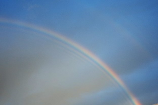
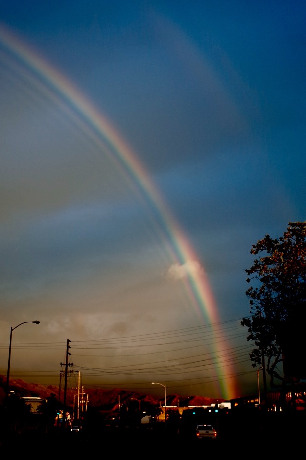
Primary rainbow with supernumerary bows and a faint secondary bow. Photo from Noboru Chikira, 21 Apr 2016, Oahu, Hawaii.
No, your vision isn’t blurred. There are actually additional colored bands bordering the bright primary rainbow in this picture from the Hawaiian Island of Oahu. These faint, pastel bands of light are referred to as supernumerary bows. “Supernumerary” means “more numerous” and is an adjective used not only for describing this optical phenomenon, but also for everything from teeth to military officers. To understand how these bands form, we first need to consider what creates a rainbow in the first place.
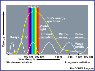
Rain showers over the tropical Hawaiian Islands, and elsewhere, can lead to vibrant rainbows. How does this occur? First, consider the energy emitted by the sun, which includes waves of energy in the UV, infrared, and visible portions of the electromagnetic spectrum. Most of the sun’s energy is emitted as visible light, which includes a range of colors (ROYGBIV).
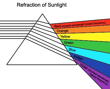
In 1665 Isaac Newton, through his infamous prism experiment, was able to prove that the white light of the sun was actually composed of a color spectrum. The sun’s visible light entered the prism and was refracted (bent) through the prism, with the red (longest wavelength) bending the least and the shorter wavelength violet bending the most.
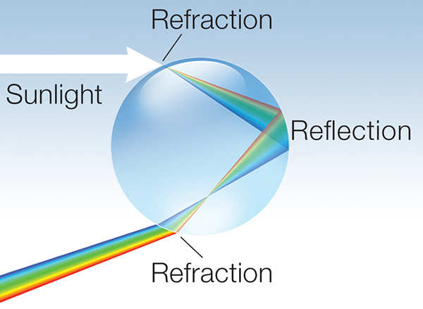
A raindrop falling from a cloud can act as a prism, bending and reflecting the light to produce the colors of the rainbow. When the sunlight encounters a raindrop, some of the light is bent as it enters the drop. This refracted light hits the back of the raindrop, is reflected internally within the drop, then is bent (refracted) once again as it exits the drop.
Because the different colors of the sunlight bends at different angles, the result of one internal reflection means the primary rainbow will have red on the outside and blue on the inside. This process happens to an assortment of raindrops falling from the sky leading to the existence of many rainbows at the same time; however, which one you see (and how much of one you see) depends on your viewpoint relative to the angle of the sun above the horizon behind you.
Sometimes, a second, fainter rainbow can be seen in the sky. This secondary rainbow results from two internal reflections (instead of one) inside the raindrop, leading to the colors appearing in the opposite order as the primary bow. In the following picture, you can see the faint secondary bow in the upper right.
Primary rainbow with supernumerary bows and a faint secondary bow. Photo from Noboru Chikira, 21 Apr 2016, Oahu, Hawaii.
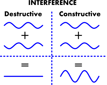
The key to the formation of rainbows, is therefore dependent on the sunlight, raindrops, and how much and how many times the sunlight bends and reflects within the drop. To understand supernumerary bows, the feature of this post, it’s important to remember that rays of light are waves of energy. Think of the ripples and waves that form on a water surface and what happens when they interact with each other. Some can counteract and destroy each other, while others can join to make a bigger wave. A similar description can be applied to waves of light.
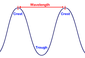
The distance between the crests of these waves of energy is referred to as the wavelength (recall red light has a longer wavelength than blue).
If the waves are in sync with each other, they can constructively interfere to amplify the wave. If they are out of sync (out of phase) with each other, they can destructively interfere to cancel each other out.
So with this in mind, given the different angles of refraction for the different colors of the sun’s rays when sunlight encounters and is bent through and around a raindrop, there is bright light where the crests of waves are aligned (and therefore constructively interfere); similarly, there is darkness where the waves of light destructively interfere. Each of the bright fringes is a supernumerary bow, created by interference between different portions (colors) of the same light wave.
Why can’t we always see supernumerary bows? Well, their presence depends on the size of the raindrops. Supernumerary bows can only be seen when the sunlight encounters small raindrops that are all nearly the same size. In a typical rain storm, there are drops falling of many different shapes and sizes, which would wash out the colors of the supernumerary bows. Basically each differently sized raindrop would produce differently spaced, overlapping fringes that would blur. There is a sweet spot, though, because as the drops become even smaller, the bow broadens, the colors become less saturated, and eventually there is no longer a vibrant rainbow but a faint cloudbow or fogbow. An excellent description of these bows and their dependence on drop size can be found here: http://www.atoptics.co.uk/rainbows/supdrsz.htm
Pileus atop cumulus congestus, Richard Barnhill (eastern MD, 12 Aug 2014)
This beautiful picture was taken by Richard Barnhill in eastern MD on 12 August 2014. The sun is highlighting the tops of growing cumulus congestus clouds, which are capped by another cloud, called a pileus cloud. Pileus is Latin for “cap” and resembles lenticular clouds that are also highlighted in this atlas. Lenticular clouds form when moist stable air encounters a mountain barrier, whereas these pileus clouds form when moist stable air is disrupted by the growing cumulus cloud below.
Strong updrafts occur within these growing cumulus clouds, defined by their well-defined edges and tufted appearance. If the air above is moist and relatively stable, but is forced upward by this strong upward motion from the cloud below, it can cool to its dewpoint, leading to condensation and the formation of this pileus cloud. This happens quite rapidly and the pileus cloud does not last long as typically the cumulus cloud beneath continues to grow through it.
Here is a schematic we created to try to simply explain this process:
Schematic showing formation of pileus (courtesy of the Community Cloud Atlas admins)
The following series of images shows another example of a pileus cloud, where the cumulus below quickly produced this cap cloud and then grow through it to form a mature cumulonimbus.
Example of cumulus growing through the pileus cloud
Here is yet another great example of a pileus cloud, sent to us from North Carolina back in May. Notice how clearly it sits atop the cumulus congestus cloud, resembling a cap cloud hugging the top of a mountain barrier.
Pileus atop growing cumulus, Blake Smith (North Carolina, 18 May 2014)
The term “pileus” isn’t unique to clouds, however. Another example of this “cap” feature is given for the tops of mushrooms, such as shown in this diagram below. It’s great to see the commonalities in nature!
“Pileus” term applied to mushrooms
Given that pileus are quite the fleeting phenomena, we are curious: have you seen a pileus? We would love to see your examples!
Jerry Tangren
Location: East Wenatchee, Washington
Date: 29 April 2013
When stable air flows over mountain ranges, the flow can oscillate with stacks of lens-shaped clouds forming in the rising areas of the motion. The image below shows a simplified diagram of this.
Note that there’s also turbulent air closer to the surface. These gusty downslope winds are not uncommon in this scenario and in fact, Jerry Tangren, who sent the beautiful lenticular photo posted above, noted that area was under a high wind warning that day. East Wenatchee is located just to the east of the Cascades in Washington State, creating a prime location to view these beautiful wave clouds as stable flow comes in at mid-levels off the Pacific.
Ming-Hwa Tang
Location: Miaoli City, Taiwan
Date: 17 June 2014
What a fun mixture of clouds over northwest Taiwan on this late spring afternoon! High above, the faint, nearly transparent clouds are Cirrus clouds made up of ice crystals. Moving down to the mid-levels are Altocumulus clouds. Note that they are slightly lens-shaped. This indicates the lenticularis variety, or more commonly referred to as Lenticular clouds. They form when relatively stable air flows over mountains, which in this case are part of the Central Mountain Range oriented N-S across this country. Heating of these mountains peaks, however, allows the sub-tropical moist air to rise to produce the shallow cumulus clouds over the high terrain. The presence of the more stable lenticular clouds aloft suggest that these cumulus clouds will be limited in vertical growth.
Radek Zek
Location: Opava City, Czech Republic
Date: 28 May 2014
When the surface warms in the afternoon sun, the air begins to rise, cooling and condensing to form clouds. This “convective” cloud formation can lead to continued growth of the cloud as long as the rising air is warmer than the surrounding environment. These cumulus congestus clouds (cumulus meaning “heap”, congestus meaning “piled up”) can eventually grow to taller cumulonimbus clouds if these conditions remain unstable.
When clouds block the sun, alternating rays of light and shadows can appear to radiate from the top or bottom of the clouds. These are called Crepuscular rays where crepuscular is Latin for “relating to twilight.” This is an appropriate name because the rays are often seen when the sun is at a lower angle in the sky, around sunrise or sunset; although, this doesn’t always have to be the case. They are actually parallel rays of light but appear to radiate outward due to perspective. In this photo,the rays and sunlight help to illuminate the well-defined, puffy tops of the cumulus clouds below.
Nicky Clarke
Location: Manchester, UK
Date: 18 June 2014
Mammatus clouds form on the underside of other clouds as the drier air below causes evaporation and the formation of these bulbous features. While commonly observed under the anvil of severe storms, mammatus themselves do not indicate severe weather and can form under clouds other than cumulonimbus, as looks to be the case in this picture from over the UK in May.
Nicky Clarke
Location: Manchester, UK
Date: Late May 2014
This featureless, layer cloud looks awfully similar to the nimbostratus clouds. What’s the difference? These stratus clouds aren’t precipitating…at least not yet. In Seattle, there’s a fine line between the stratus clouds and the lightly raining nimbostratus. These clouds form in relatively stable layers so the drops in the cloud don’t get as large as those in the heavily raining cumulus clouds for example. Have an overcast sky with no rain? There are stratus clouds not far above you!
These are thick enough that you can’t see the sun through so technically they are of the variety Opacus.
Angela Rowe
Location: Seattle, Washington
Date: May 2013